Kieran Baxter/National Trust
Hillfort atlas wins industry recognition at international conference
An Oxford research project mapping all the hillforts across England and Ireland, has been lauded by industry leaders at the American Association for the Advancement of Science (AAAS) conference, Austin, Texas, as one of the best examples of multidisciplinary research in the UK.
Selected as the only Arts and Humanities Research Council (AHRC) funded project to be presented at the AAAS Conference, the atlas was built in collaboration with the University of Edinburgh and the support of citizen scientists across the country. The survey was five years in the making and includes information on all of the hillforts in Britain and Ireland – 4,147 in total, collated into a publicly accessible website.
The AAAS Conference attracts more than 8000 delegates from broad ranging fields including academic science, government policy and more general interests.
Professor Gary Lock, co-principal investigator on the project and Emeritus Professor of Archaeology at Oxford University and John Pouncett, also of The School of Archaeology, Oxford University, attended the event alongside Professor Ian Ralston co-principal investigator and Professor of Archaeology at Edinburgh University, to demonstrate the atlas to attendees who also included school age children and their parents.
Professor Lock said, ‘To be chosen as the single project to represent the AHRC at the AAAS is an incredible honour that verifies the importance of our work and shows the leading position of archaeology within international humanities and scientific research.'
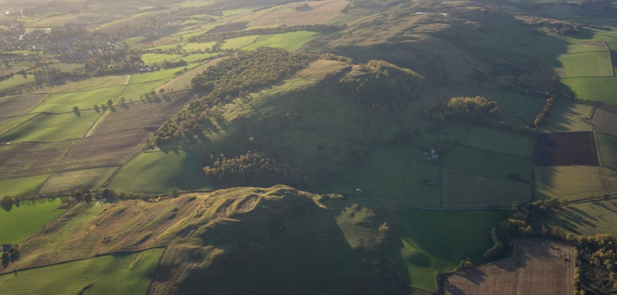
The unique resource provides free access to information about world-famous sites as well as many previously little-known hillforts, helping ramblers, cyclists, naturalists, and history enthusiasts discover them and the landscapes around them.
Mostly built during the Iron Age, the oldest hillforts date back to around 1,500BC and the most recent to around 700AD. Hillforts played a pivotal role in more than 2,000 years of ancient living and served various functions, such as defence and communal gathering spaces, while other uses have yet to be fully understood.
Terry O’Connor, Communications Director at the Science and Technology Facilities Council and lead for the UKRI AAAS campaign said: ‘We selected the Hillforts Atlas exhibit as an excellent example of the best of UK multidisciplinary research – combining archaeology, remote sensing, citizen science and other techniques to provide not only a new research tool but an exciting way of engaging the public with research. The team of Gary, Ian and John were fabulous ambassadors for the project, their science and their universities.’
Mike Collins, Head of Communications at the Arts and Humanities Research Council, said: 'The Hillfort Atlas project was the ideal fit for the AAAS conference in Texas as it showcases brilliantly the use of technology to tell the story of hillforts across the UK and Ireland. The Atlas was one of the public engagement hits of 2017 with hundreds of thousands of people visiting the website and an amazing reaction in the media and through social media. It's been a great example of how years of hard research work can pay dividends and get the public excited about the history of where they live or a place that they love to go on holiday too.'
Since its launch in June 2017 the Atlas website has been a tremendous success with the general public, students, academics and a range of environmental specialists. The site is still being developed with new functionality and analytical capabilities to be added.
Fort finder: An atlas of the hillforts of Britain and Ireland:
About OxSciBlog
The Oxford Science Blog gives you the inside track on science at Oxford University: the projects, the people, and what's happening behind the scenes. Curated by Ruth Abrahams, Media Relations Manager (Research and Innovation).
Contact: Ruth Abrahams, [email protected]