Can remote sensing help us to protect coral reefs?
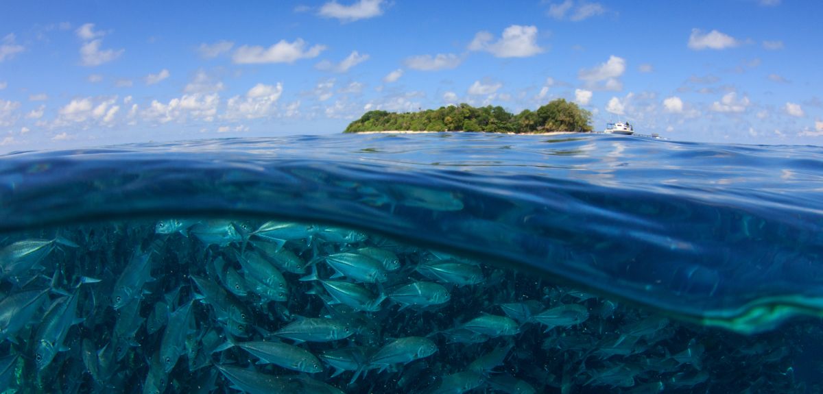
Coastal communities depend on a healthy coral reef ecosystems for food, clean water, commerce, and culture. These reefs are also home to a rich diversity of tropical fish and other vibrant species. Among the range of threats posed to coral reefs, warming ocean due to climate change is among the most concerning.
A new study led by Lisa Wedding, Associate Professor at the University of Oxford’s School of Geography and the Environment, uses remotely sensing to illuminate coral reef complexity and biodiversity. This research published recently in Remote Sensing in Ecology and Conservation, uses a novel approach by combining 2D and 3D seascape models to identify complex reef structure, and the populations of fish living within them. Creating cost effective and accurate methods of identifying coastal “hotspots” is an essential step in the creation of effective management plans for marine protection and conservation.
“Mapping and placing value on reef areas that represent biodiversity hotspots are important for coastal communities that rely on healthy reef fish populations for food, tourism and culture. This information can help to inform urgently needed management actions to sustain healthy reefs and healthy coastal communities,” said Wedding.
The team took to their SCUBA gear and dove on 625 coral reef sites in order to inform their seascape models. The divers tallied the type and length of each coral reef fish species present. The researchers then harnessed satellite data to create 2D habitat maps at each site. While used widely in the past, using 2D satellite data for coral reef mapping has limitations, as only planimetric (or horizontal) areas of habitats are accounted for rather than the total complex 3D structure. In the case of coral reefs, elaborate habitat configurations indicate higher potential for biodiversity, a chief indicator of a healthy ecosystem.
The team turned to a technology called LiDAR (light detection and ranging), a remote sensing tool that uses light in the form of a pulsed laser to measure variable distances. This allowed them to create 3D models, bringing to life the true complexity of the coral reef seafloor. Equipped with this information, the researchers were able to create predictive models of the reef fish community, based on the collected habitat data. Surprisingly, the most effective model was a combination of the 2D and 3D LiDAR satellite data, which most accurately predicted coral reef fish diversity, biomass and density.
“We found that 2D characterization of the seafloor does not capture the intricate relationships between reefs and fish communities, and the application of LiDAR in this work helps to advance seascape ecology theory and application in the third dimension," said Wedding.
The researchers also found that marine protected areas consistently demonstrated higher fish diversity and biomass. This suggests that creating marine protected areas where complex 3D reef structures exist may be key in establishing more resilient ocean ecosystems, able to recover more quickly from future bleaching events or other damaging forces.
“Understanding the seascape from a 3D perspective offers great potential to advance our knowledge of coral reefs,” Wedding said. “LiDAR remote sensing allows us to capture the intricate 3D vertical structure of coral reefs and understand wherehabitats have high conservation value to inform future ocean planning efforts. Our research supports the design of marine protected areas in these locations, which should be a management priority, as habitat complexity can enhance reef resilience and recovery.”
 Expert Comment: From frontier to feedback loop - Why space must become circular
 Blood test may improve survival of childhood cancer in Africa
 University of Oxford receives further £2m gift from Fondation Docteur Sadok Besrour to strengthen academic primary care in Tunisia
 Oxford University spinout Dark Blue Therapeutics acquired to advance leukaemia treatment
 Expert Comment: Ethics-washing and Us-washing