Oxford archaeologists win access to restricted satellite images of Israel and the Palestinian territories
Satellite images of the earth’s surface are familiar. From Google Earth to estate agents’ websites, space age technology is used to bring us images of the world in which we live. And there has been regular exciting news from archaeologists about an entire new city or settlement discovered in the desert or on a remote hilltop, lost to generations, found thanks to satellite imaging.
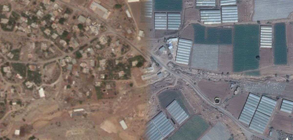
There are pictures of almost every country on Earth, from space. But there has been one key area which it has not been possible accurately to view with satellites, frustrating archaeologists keen to study the region. That area is Israel and the Occupied Palestinian Territories (OPT) - a region packed with the history of ages and civilisation, where feet really did walk in ancient times.
There has been one key area which it has not been possible accurately to view with satellites, frustrating archaeologists keen to study the region. That area is Israel and the Occupied Palestinian Territories (OPT) - a region packed with the history of ages and civilisation, where feet really did walk in ancient times
A long-standing prohibition in the United States, known as the Kyl-Bingaman Amendment, meant that archaeologists studying the region could not use US satellite technology – which was the main source for many years, although Israel itself put good quality images of its territory on its own mapping agency website.
Two Oxford archaeologists, Dr Michael Fradley and Dr Andrea Zerbini, decided to do something about it. And recently, following concerted effort over several years, reform of the prohibition was allowed. Restrictions over the sale of US high-resolution satellite imagery over the region was reduced on the Federal Register on 21 July. It was a significant victory.
Dr Fradley maintains, ‘This ruling opens up many opportunities for research for archaeologists and many other disciplines which use Earth observation, such as for monitoring evidence of climate change and water exploitation. And it is a big win for science...
‘A century ago, the Cambridge botanist Hugh Hamshaw Thomas, who served as an RFC/RAF intelligence officer on the Palestine front during the First World War, highlighted the value of aerial photography for scientific study in the Levant in a paper in the journal Nature. But this potential has rarely been achieved. Hopefully, this long-overdue reform will help reverse that trend with regards to more recent satellite imagery’.
This ruling opens up many opportunities for research for archaeologists and many other disciplines which use Earth observation, such as for monitoring evidence of climate change and water exploitation. And it is a big win for science
This reform success has been hard-fought. It all started because the Oxford pair came up against the barrier. Their work was part of the Arcadia-funded, Endangered Archaeology of the Middle East and North Africa (EAMENA) project. It uses satellite imagery to identify and monitor archaeological sites across the MENA region.
Three years ago, they found most archaeological sites in the OPT were not visible on the available low-resolution imagery. According to Dr Fradley, ‘It was a major barrier to our work. The imagery available was very low resolution – because of the US restrictions. We decided to find a way around it.’
They did find a way. The Kyl-Bingaman Amendment contained a reform mechanism that meant restrictions would be lowered, if companies outside the US were selling their own satellite imagery at a higher resolution than the level set by the US restrictions. And things had changed.The US was no longer the only supplier; Airbus provided imagery. The archaeologists found the French company had been producing sub-2m resolution of Israel from at least 2012. But nobody in the US had been effectively monitoring the situation. Since that time, several other companies outside the US had also surpassed the 2m level, including the South Korean company Kompsat. But, from an academic perspective, US satellite imagery offered the potential for open-source free access – essential for academic uses.
The Oxford pair tried to argue their case, with little response – although no one in the scientific community argued that the restriction should be retained. But they persevered, publishing an agenda-setting paper on the restrictions in the journal Space Policy and working with the Washington-based policy group al-Shabaka. Finally, the US regulator relented, lowering to the restricted level to 0.4m as the archaeologists had argued, a level achieved by the Kompsat K3A satellite.
The decision to lift the prohibition has ‘huge implications', according to Dr Fradley. ‘We haven’t been able to access some areas in occupied territories and this will make an enormous difference.
‘We will be able to record archaeology of the region on a granular level and have a much more objective view. We will be able to see if there has been damage to sites and, potentially, [if they secure access to retrospective imagery] identify where sites have been lost.’
The decision to lift the prohibition has ‘huge implications’, according to Dr Fradley. ‘We haven’t been able to access some areas in occupied territories and this will make an enormous difference.
Dr Fradley explains, ‘Israel has its own mapping of the entire country and a well-developed and well financed antiquities authority...but we haven’t had accurate imagery for the OPT. More data is of more benefit.’
Commenting on the news, Dr Jack Green, Associate Director of the American Centre for Oriental Research, based in Amman, Jordan, says, ‘The release of this more detailed satellite imagery will help provide many archaeologists and cultural heritage professionals with the vital additional tools needed to document and monitor sites and landscapes under their care from continual threats of urban encroachment, agricultural development, looting, vandalism, and other unauthorized activities. This is especially important for monitoring areas which are difficult or impossible to gain access to for security reasons.’
Dr Carol Palmor, Director of the Council for British Research in the Levant, also based in Amman says, ‘This represents an essential step for the protection of heritage in Israel and Palestine, with profound implications for many years to come. Furthermore, it is a brilliant example of the impact of research on policy and international legislation.’
This represents an essential step for the protection of heritage in Israel and Palestine, with profound implications for many years to come. Furthermore, it is a brilliant example of the impact of research on policy and international legislation
This successful reform has been bittersweet. In July last year, Dr Andrea Zerbini passed away of a rare cancer at the age of 34, when it still appeared that the restrictions would not be lifted. The present reform would have delighted him, and the decision is a lasting tribute to the research in Space Policy, in which he was a prime mover.
About Arts Blog
The latest news and views in the arts, humanities and culture at Oxford University. Curated by Sarah Whitebloom, Media Relations Manager (Research and Innovation).
Contact: Sarah Whitebloom, [email protected]