Image credit: Shutterstock
New software predicts the movements of large land animals
New software can help determine the movements of large wild animals, thereby minimising conflicts with people.
Large land animals have a significant impact on the ecology and biodiversity of the areas they inhabit and traverse. If, for example, the routes and stopping places of cattle, horses, sheep, and also those of wolves or bears overlap with those of people, this often leads to conflicts.
Knowing and being able to predict the movement patterns of animals is, therefore, of utmost relevance. This is not only necessary for nature and landscape protection, and to safeguard agriculture and forestry, but also for the safety of human travellers and the security of human infrastructures.
Traditional maps of animal movements are mostly based on long-term surveys of so-called telemetry data; this comes from individuals fitted with radio transmitters. This type of map-making is often time consuming and expensive, and lack of radio contact in some areas means that no data can be collected at all.
The new software created by the researchers - named ‘enerscape’ – is able to create these maps easily and cost-effectively. It is simpler than measurements obtained using radio transmitters and can be used where conventional methods fail. An international team led by the German Centre for Integrative Biodiversity Research (iDiv), the Friedrich Schiller University Jena, Aarhus University and the University of Oxford has published a description of the new software in the journal Methods in Ecology and Evolution.
Dr Emilio Berti, post-doctoral researcher with the Theory in Biodiversity Science research group at iDiv and Friedrich Schiller University Jena and first author of the study, said: 'What’s special is that the software requires very little data as a basis. The energy an animal needs to expend to travel a certain distance is calculated, based on the weight of that animal and its general movement behaviour. This energy expenditure is then integrated with the topographical information of an area.
'From this information we can then create ‘energy landscape maps’ for individuals as well as for groups of animals. Our maps are calculated rather than measured and thus represent a cost-effective alternative to traditional maps. In particular applications, such as the conditions in the Italian national park, our method makes the creation of movement pattern maps actually possible at all.'
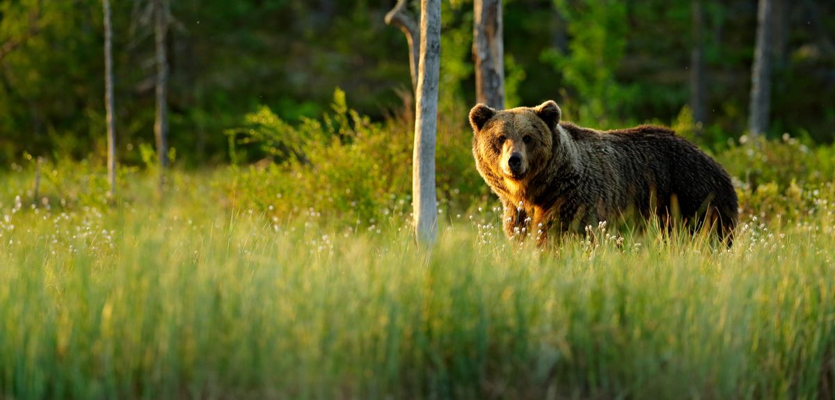
The software was tested in the Abruzzo region of Italy, the location of the Sirente Velino Regional Park, which is home to the endangered and therefore protected Marsican brown bear (Ursus arctos marsicanus). Recording the bears' patterns of movement in the 50,000 hectare, partly populated area is especially important for their own protection, but also for that of the people living there and the sensitive flora.
Using enerscape, the researchers found that bears choose paths that require less energy expenditure. These paths often lead through settlements, so that the bears encounter humans – which frequently ends fatally for the animals. The software also predicts, that bears wanting to save energy will tend to stay in valleys, far away from human settlements. Bear conflict as well as protection zones can now be identified using enerscape. Its maps can also be used to check whether landscape elements are still well-connected enough to enable the animals to move around the area sufficiently.
The researchers' software enerscape is based on the widely used and openly accessible programming language ‘R’. It has a modular structure and can therefore process animal movement and topographical data from a wide variety of ecosystem types.
'This makes it possible for both researchers and wildlife managers to adapt the software to a wide variety of landscapes and animals,' said Professor Fritz Vollrath from the Department of Zoology at the University of Oxford and senior author of the study, emphasising the special nature of enerscape.
'This means that the number of maps of animal movement in landscapes will increase in just a short time. With significantly more cartographical data, the understanding of the behavioural ecology of a species in a certain habitat will also fundamentally change. This will primarily benefit nature conservation and, in particular, rewilding measures – the reintroduction of wild animals.'
The development of enerscape was supported by iDiv which is funded by the German Research Foundation. In addition, enerscape is part of the VILLUM Investigator project ‘Biodiversity Dynamics in a Changing World’, which is funded by the Danish VILLUM Foundation and its ‘Independent Research Fund Denmark | Natural Sciences Project MegaComplexity’.
 New study on Amazonia's fire crises urges action ahead of the next burning season
 New heart disease calculator could save lives by identifying high-risk patients missed by current tools
 Modern Slavery and Human Rights Policy and Evidence Centre moves to Oxford University after receiving continuation funding
 Study shows that island bats are valuable allies for farmers
 Study reveals how humanity could unite to address global challenges